I’m about to release a new version of Maps and Semantic maps. Since it does not feature any mayor structural changes, it’ll be added to the 0.3.x branch, and so become version 0.3.3. This version features some small, but important bug fixes, some code improvements, and also some new features.
New features
- GeoNames geocoding support. Since the initial release, me and Yaron have been searching for an open source geocoding service that’s completely free to use. Such a service is needed cause a lot of people do not want to use Google Maps or Yahoo! Maps cause of their licences. We did quite some searching, but didn’t find anything decent. While discussing an issue about DMS notation on one of the wiki mailing lists, Joel Natividad suggested using GeoNames.
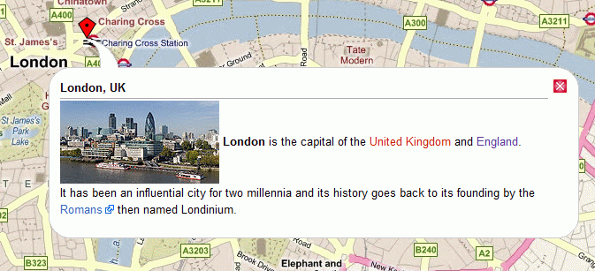
- Wiki mark-up support for the title and label parameters. One common request for Maps has been to add the ability to display images in pop-ups. The value of both parameters now gets parsed as wiki text, enabling you to pass along links, images and other wiki mark-up. I’ve created a to-do related to this: enable to pass along complex wiki mark-up. This is currently not possible, since Maps can not determine if a property separator (|) is part of one of it’s parser functions, or one nested in it. This makes you unable to specify the location, width, height, and other properties of an image.
Bug fixes
- Some very small bug (a = b instead of a == b) in a function used to determine the geocoding service. This caused the ‘default override mechanism’ that I put into place, to prevent Maps from using a licensed geocoding not together with the related mapping service when no geocoding service was provided. Cause of teh error, it always got set the the Google geocoding service.
- Implemented missing method getName in the Query Printer handler for the map result format. The absence of this function caused some errors to be displayed on the Special:Ask page.
Refactoring
- I refactored up some common functionality from the geocoder classes to the base geocoder class, after Yaron suggested doing this. Not a big deal, but still nice.
- Yaron changed the default zoom for OpenLayers maps.
If no more small, or easy to fix bugs or feature requests trun up, the next release will be 0.4, which will feature some big new functionality, like defining custom base layers (for OpenLayers), custom overlays, lists of points next to the maps and probably also a thoroughly revised hook system.

Hi Jeroen,
geonames implementation is exactly where we were waiting for.
We are using geonames in two of our wiki’s.
However, I installed maps3.3 and it throws me an error: Fatal error: Call to undefined function curl_init() in /home/webstuff/wikis/wikihier/extensions/Maps/Maps_BaseGeocoder.php on line 29 when I enter: {{#geocode:Moscow, Russia}}.
Any help?
JosNederland.
Hey,
That sounds like a PHP issue. That function requires PHP 4.0.2 or above, or PHP 5.x. Are you using an older PHP version?
Cheers
5.2.4-2ubuntu5.6 (apache2handler)
on the other wiki we are using maps2.0 and all is ok.
Bedankt
Hey,
Can you tell me the PHP version you are using? The change since 0.2 was made to increase security, and also to avoid issues with server settings. A small change could easily be made to the script to detect the PHP version, and use the curl request only when it’s equal to or bigger then 4.0.2. So it’d be great if you could confirm the usage of an old PHP version is the cause of your problems 🙂
Cheers
Hi Jeroen,
PHP 5.2.4 as I mailed you.
btw were you born in Holland?
Cheers too.
Hallo Jeroen,
wil je me je emailadres mailen?
Dan stuur ik je een link naar onze wiki’s. Ze zijn nog under development, dus ik wil ze liever nog niet openbaar maken.
Mijn email is josvanderven at hotmail dot com
Fantastische applicatie heb je gemaakt trouwens, en doe de groeten aan Yaron.
Hey,
Mailed you.
In that case it’s not a PHP version related issue, but probably is caused by different server settings or something similar. I’ll look into this further tomorrow 🙂
Cheers