An early beta of the next big release of the Maps and Semantic Maps extensions is now available for download. The most notable new features in this release are tag extension support for all the Maps parser functions, more consistent error handling via Validator 0.4 and compatibility with the upcoming MediaWiki 1.17. Most changes are internal improvements, but there are also several bug fixes and minor new features.
Both extensions need some more polishing work before the 0.7 release, some testing needs to be done, and some small new features might still be added. This is a list of changes so far:
Maps
New features
Tag support for these parser hooks (which previously only had parser function support):
- Coordinates
- Distance
- Finddestination
- Geocode
- Geodistance
Bug fixes
- Fixed compatibility with the MW 1.17 resource loader.
- Fixed i18n issue with the overlays control for Google Maps v2 maps.
- Fixed default zoom level for Yahoo! Maps maps.
- Increased the maximum decimals for DMS coordinates from 2 to 20.
Removed features
- #geocodelong and #geocodelat parser functions – you can obtain their functionality using #geocode.
Internal improvements
- Rewrote the geocoding functionality. It’s now an integral part of the extension that can not be just pulled out, while the reverse is true for individual geocoders. Geocoder interaction now uses the same model as mapping service interaction.
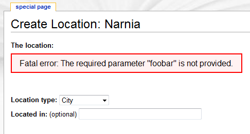
- Use of Validator 0.4, allowing for more robust and consistent error reporting.
- Rewrote the parser hooks to use the ParserHook class provided by Validator.
- Restructured the directory structure of the extension to better match it’s architecture.
Semantic Maps
New features
- Added ‘locations’ parameter to the map query printers that allows for displaying static locations in addition to query results in queries. It behaves the same as the locations parameter in display_points.

Bug fixes
- Fixed compatibility with the MW 1.17 resource loader.
Internal improvements
- Use of Validator 0.4, allowing for more robust and consistent error reporting.
- Restructured the directory structure of the extension to better match it’s architecture.
Notice
Although the big features should work, this release will probably contain multiple issues. Please report any you might find.
For the most current version of this announcement, see the original on the mapping wiki.